Backpacking to Pacheco Falls in Henry Coe State Park

I decided to plan a short backpacking trip in Henry Coe since we haven't done any trips in a while. Henry Coe State Park is only about an hour away, doesn't require reserving permits in advance, and has lots and lots of trails. The Sierras are very nice but I'm too lazy to make the drive up for two days of backpacking.
Trip stats
Dates: May 27 - May 28, 2023
Distance: 22.5 miles
Elevation: +/-5500 ft
Weather: ~45-80F — sunny day 1, foggy and windy day
Permits required: Self registered
Bear cans required: No
Map: https://caltopo.com/m/G143K

Trail description
Henry Coe is the second largest state park in California (after Anza Borrego). It is located in the Diablo Range and is less than an hour's drive from San Jose. It has a huge network of trails that are good for backpacking, but isn't too crowded, and doesn't require reserving permits in advance.
I was surprised by the amount of water here — normally these types of hills feel very dry, but there were springs and lakes scattered throughout the park. We probably didn't have more than a 5 mile stretch without passing a water source. All of the trails that we hiked were either wide dirt roads or very narrow trails through tall grass, with nothing in between. Apparently ticks are common, but we didn't see any.
Since it was Memorial Day weekend, the park was probably on the busier side. We passed many hikers on the trail, and the camp sites were fairly crowded.
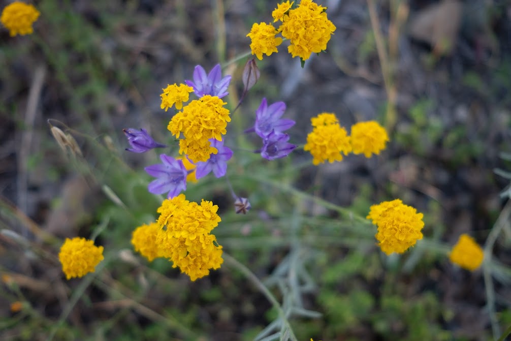
While we were hiking I noticed a lot of wildflowers that I'd never seen before, so at some point I started trying to take a picture of every flower I saw, which will be evident later on in this post. I will also make an attempt at identifying them.

Trail log
Day 1: Hunting Hollow to Pacheco Falls (10.7 miles, +3300 ft, -2600 ft)
We had a late start in the morning and arrived at the Hunting Hollow parking lot at 12pm with a vague notion of the route we wanted to hike. There were lots of cars in the parking lot but there were a few spots left for us. We went to the information board to do the self registration and found a pamphlet with instructions for the Pacheco Falls loop hike, which we ended up using to get the route up to the falls. We also completely forgot about bringing cash for the permit, so we had to put in a 20 dollar bill for the $16 permit.

The hike starts off with the Steer Ridge trail, which appears to just go straight up the side of a hill. It's steep and narrow, and there's dry grass on both sides, causing hiking poles to continually get stuck in the grass. It was hot and extremely bright, which makes sense given that we started around noon.


About a mile in, the trail levels off to a milder climb until it reaches the top of the ridge.


The hiking became nice and flat after we got to the top. We passed Willson Peak, which doesn't feel like much of a peak, as it's a flat topped hill right beside the trail. However, it had two summit markers.


I liked the rocky outcrop covered in poppies. There were lots of other California poppies on this hike, too, but this was the most notable occurrence.


After Willson Peak we turned left onto Serpentine Trail, which went back downhill until Grizzly Gulch Trail, where we turned left. The next point of interest was Tule Pond. I guess you could filter water here. According to the pamphlet you could also camp here in the meadow by the pond.


There was a little creek crossing right after Tule Pond.


We stopped for a late lunch (3:30pm) at Wasno Pond. We found a log on the far side of the pond to sit on although there wasn't much shade. For lunch we had turkey and cheddar sandwiches. This is also a potential camping spot and watering spot.


After lunch, the trail continued along Wagon Road until the turn off to get to Pacheco Falls. Our original plan was to visit Pacheco Falls and then continue hiking along to Coit Lake, and camp there. But looking at the time, we realized we probably wouldn't make it to Coit Lake by sunset, and we wouldn't have any time at the falls.


We turned right onto Pacheco Falls Trail for the last downhill section. We passed by Wood Duck Pond, which is the recommended camping spot. There were already several tents here, so we decided to continue to the falls and see if there were any good sites on the way there. I was disappointed to see no wood ducks in Wood Duck Pond. There were however several red-winged blackbirds and coots.


We reached the falls at around 6pm. There weren't many flat spots for camping on the way down but we did see a potentially flat area with some oak trees. There were mosquitoes by the pool. We sat for a bit and filtered water. The water didn't look as appetizing as a mountain lake but it was ok. There were also some fish swimming around.


We ended up going to the site that we saw on the way down. There was a lot of tall grass there and we had to trample some of it to set up the tent which you're probably not supposed to do. There were still some mosquitoes here so we didn't really want to go outside. We cooked out the side of the tent, which you're also not really supposed to do. For dinner we had instant mac and cheese and a bagged salad.


Day 2: Pacheco Falls to Coit Lake to Kelly Lake to Hunting Hollow (13.5 miles, +2300 ft, -3000 ft)
We woke up at around 6:30 because of the sunrise, and the fact that we didn't use a rain fly on the tent. For breakfast I had my coffee and we had some granola. We left camp at 8am.


The climb out of the Pacheco Falls area wasn't too bad. We followed Coit Ridge Trail and took a small detour to Pacheco Camp, to see what it looked like. There was one group there and a few falling apart shed-like structures.


Coit Ridge Trail continues down to Coit Lake. Coit Lake was very large. We passed by one of the camp sites, which had a pergola with a picnic table underneath, and a bathroom not too far away. There was one group camped here. The weather was becoming increasingly cold and foggy.


Then from Coit Lake it was a short walk to Kelly Lake. There were tons of people camped here. Most people were camped on flat areas by the lake or on the tops of hills. It looked like a lot of tents were on slopey ground. There were also several people fishing. According to the Henry Coe website this lake contains bass, bluegill, green sunfish, and crappie. Coit Lake also has these fish, but for some reason was much less crowded.


After Kelly Lake we took Kelly Cabin Canyon Trail toward Wasno Pond. This trail was a narrow and grassy trail that followed a little creek through a canyon. At times you could not even see dirt on the trail as it was covered in trampled grass.


Apparently there are wild pigs in the park, and wild pig traps. This trap didn't appear to be in use, though, as the door was locked to the side.

The next stop was Willson Camp. Here there was some sort of wooden shelter with a picnic table underneath. A group had left their stuff (one tent, two bivies, backpacks, socks hanging on the wall). We had a noontime lunch here (sandwiches again).


Just past Willson Camp there was a spring.


The rest of the hike followed Lyman Willson Ridge Trail back to Hunting Hollow Road. The trail was flat along the top of the ridge for a while before going to a steep downhill. At one point we saw this unnamed pond (on my map it showed up as "C93"), which looked very nice.
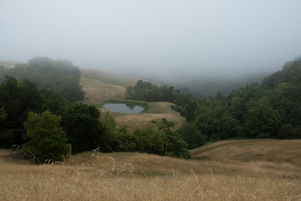


The hills looked nice in the fog. We saw lots of Valley Oaks here. A lot of them had red fruit-like things on them, which I later learned were oak galls. Oak galls contain an oak gall wasp larva inside, and they grow because the wasp secretes some chemical that causes the plant to grow these things.


The last half mile of the hike is on Hunting Hollow Road, which is flat and has multiple stream crossings. The stream crossings were mild and I never had to get my shoes wet because of conveniently placed stepping stones, but the trail pamphlet said that to avoid stream crossings one could detour onto a hillier trail.
We reached the parking lot at 2:30pm, which felt like good time for a 13 mile day.